Saturday, November 21, 2015

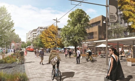
Copenhagenize Nashville?

Please click on link below as the pictures are so informative but won't copy into this blog well.  (Big thank you to Mike for sending this article my way - it is spectacular!)

Nashville, we are working hard to get you sidewalked and to change the culture to a walking one.  I am personally 2 years into this project.  Change has been slow but our new mayor seems interested in increasing funding for sidewalks - a step in the right direction.

Now is the time to contact your council person and discuss with your neighbors where sidewalks are needed in your community.

In regards to culture, since there has not been a major public health campaign to educate drivers that pedestrians do, in fact, have the right of way - please learn now that you are to yield to them if driving.  Even though there is no law - give them 3 feet as you would bicycles.  

Thank you for being interested in walkability in Nashville!

Copenhagenizing Paris


I'll be speaking in Paris today - 21 November 2015 - about bicycle urbanism and lessons to be learned from Copenhagen.

Paris has declared that it aims to be the world's best bicycle city in the world by 2020. This is simply not possible with the current sub-standard understanding of Best Practice infrastructure. The current Mayor Anne Hildalgo, has some good ideas, which we've reviewed here, but until the City understands the basics of bicycle infrastructure,  not much is going to happen.

While there are good examples of the City employing Best Practice infrastructure (above left) there are still strange things imagined in the heads of engineers and planners who have little idea of how to do it. Like the weird bi-directional stuff you see like above, right.

Or using bus lanes as bicycle lanes on long boulevards where buses can get up to speed (above, left), or strange turn lanes like atabove, right.

Best Practice has been established. It's ridiculous to try and reinvent the wheel. Copy-paste. It's that simple.


If the iconic Champs-Élysées were to be done properly, it would look a bit like this. We would probably run a wide, green meridan down the middle to further reduce the traffic so it didn't keep on looking like a Robert Doisneau photograph from the 1950s:

It's all so simple. Paris should realise that.

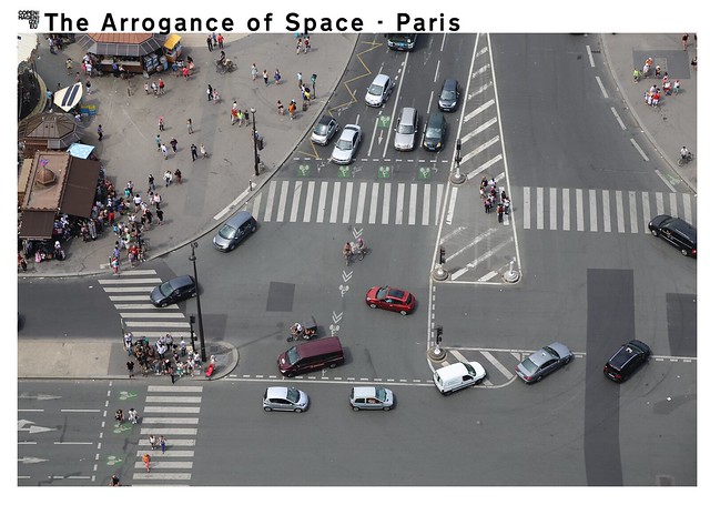
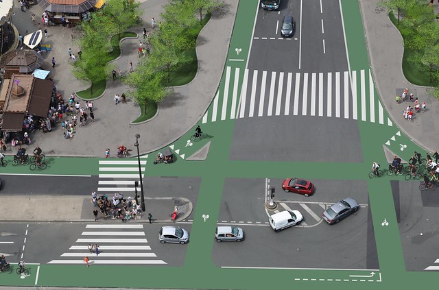
We have covered The Arrogance of Space related to Paris in this article. Using as an example the intersection, above, below the Eiffel Tower. You can see the Arrogance of Space in that link. But what would it look like if proper infrastructure were applied?


Safer, better, more modern. A total redemocratisation of the urban space. Benefiting pedestrians and cyclists and taming the most destructive force in cities - the automobile. This is designed for humans. Not engineered for cars.

It's simple if Paris wants it to be. If they dare to do it. Without this kind of redesign, they will do little for modernising transport in the city.


Link:
http://www.copenhagenize.com/2015/11/copenhagenizing-paris.html


Wednesday, October 28, 2015

What Does Our Current Sidewalk Infrastructure Say About Us?

'When the public realm is vibrant, beautiful, and active, it is a demonstration that the local government values its citizens and their quality of life.  Alternatively, when the public realm is neglected, badly designed, or treated as an after through, it reflects poorly on the city, effectively sending a message that the government does not value its citizens or its visitors.  At the Design Trust, we believe that well-designed, beautiful public spaces have the power to restore a sense of dignity to our urban environment, enrich our civic life and foster a sense of ownership in local residents.'

- Megan Canning
Deputy Director
The Design Trust for Public Spaces
http://designtrust.org


***

Downtown Nashville is flourishing (http://www.nytimes.com/2015/10/14/realestate/commercial/nashvilles-skyline-being-rebuilt-by-building-boom.html?_r=0) but what about the other highly valuable centers of Nashville?  I am arguing that we need a cohesive and well designed sidewalk plan to connect our city & we need to establish permanent funding in order to complete the task.  


In Green Hills:  A 'premiere' shopping destination


Can Nashville make public spaces like these a thing of the past?  Can we stop talking about building sidewalks and actually get to the work of it?  

There is a huge latent demand for real walkability:  sidewalks that connect to destinations, are highly functional, safe, and have beautiful design.  

Please let your elected officials know your thoughts or share this post!  The more people who care about walkability in Nashville, the better.  


Tuesday, October 27, 2015

This is Embarassing - See How Nashville Compares: Our Average Utilization of Active Transport Compared to National Average + Other Cities


I show this graph and include the brief info from a New York Times article below to argue that we need dedicated funding for active transportation infrastructure (walking, biking, public transportation) here in Nashville.  

We don't currently have this:  every year, the funding has to be asked for - there is no guarantee and this leads to instability and difficulty in setting long term plans.  Hence, we haven't planned well and we now experience the situation where buses let you off on small concrete pads that connect to nothing on very busy streets and we have 1/8 of mile of sidewalk for every mile of roadways.  Every complains of traffic.  And yet, in our neighborhoods, we have major connector streets lacking sidewalks that could lead residents to walk to run errands, but are instead lined with dangerous ditches.   

Nashville is experiencing a boom and yet are missing the opportunity to harvest some of this revenue to create a superior  walking experience.  

I'd argue that there is no great walking city in the South...why not make Nashville the first?


Nashville’s Skyline Being Reshaped by Building Boom


NASHVILLE — A powerful surge in construction is reshaping the physical character and economy of this 236-year-old river city, and fueling a deepening public conversation about essential civic values that many residents worry could be lost.

More than 100 new projects, together valued at more than $2 billion, are underway in Nashville or planned to start next year, according to city figures. Most of the big projects — four hotels, five office buildings and eight high-rise residential towers with a total value of $1.5 billion — are in the downtown core, a number of them rising on former parking lots, according to the Nashville Downtown Partnership, a business development group.
LINK:

http://www.nytimes.com/2015/10/14/realestate/commercial/nashvilles-skyline-being-rebuilt-by-building-boom.html?_r=0


Now, is the time to write your mayor and call your councilperson...If they do not know your wishes for better walkability - they won't act.  


Friday, September 25, 2015

Crowd-Sourced Map - Lets you vote on where infrastructure is needed most


Slowly, I am working on The Sidewalk Foundation website...it is going to have a map where Nashvillians can drop a pin in the locations they think most need sidewalks.  

There will also  be a place to make a donation.  Nashville is booming.  But we are not putting in the infrastructure to make this the best walking city in the South.  Funding seems to be the major impediment to walkability.  We, as a city, can change this...


How a crowd-sourced map changed Kuala Lumpur’s ideas about cycling


How do you go about making a city where 93% of households own a car more bike-friendly? By crowd-sourcing a cycle map – and getting the mayor on board


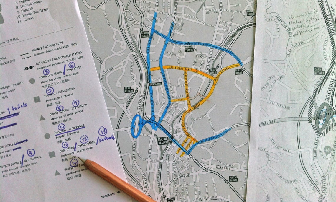
“Cycling not for leisure, but for transportation, for utility” ... the workings of Jeffrey Lim’s cycle map of Kuala Lumpur.

‘Cycling – not for leisure but for transportation, for utility’ … At work on the KL cycle map. Photograph: Jeffrey Lim


Friday 18 September 2015 03.08 EDTLast modified on Thursday 24 September 2015 10.24 EDT


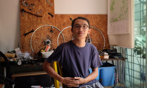
“I was a bit naive,” admits Jeffrey Lim. “I thought it would be easy.” In Lim’s bright studio in Kuala Lumpur, bike wheels adorn the walls and a large table is spread with maps of Malaysia. Lim, a graphic designer, has spent the past three years mapping the city for cyclists.

To anybody familiar with Kuala Lumpur’s urban sprawl, “naive” might seem like an understatement. As residents will tell you, this is a city built for cars. According to Nielsen, Malaysia has the third highest rate of car ownership in the world – a whopping 93% of households own a car.

“We were a nation which built bicycles. But we forgot,” says Lim. In the 1960s and 70s, rapid urbanisation in Greater Kuala Lumpur saw new highways straddle the city and the suburbs. In the 80s, the invention of a “national” car sealed Kuala Lumpur’s fate as a motorised metropolis.

Yet in recent years, a group of determined cyclists have taken to the roads nonetheless. At night or early in the morning, drivers and motorcylists might be startled to see a convoy of cyclists suddenly appear. Lim – a youthful looking man with spectacles and a focused demeanour – is often among them, helping to shepherd the group.


Every week, new people came. I stopped counting when it went over 50Jeffrey Lim
FacebookTwitterPinterest ‘I was a bit naive. I thought it would be easy’ … Jeffrey Lim. Photograph: Ling Low

Lim first got the idea for a bicycle map in early 2012. He wanted to show how the city could work for cycling – “not for leisure, but for transportation, for utility.” Knowing that most people thought of cycling as “impossible” in the city, he envisioned the map as a tool for advocates. “It was aspirational,” he says. “Because the map would have to come before the infrastructure.”

After getting the word out, Lim designed a blank map of the city to hand out to volunteers. With no dedicated cycle lanes in the city, the idea was for people to explore the routes that were at least possible to cycle, from major roads to unmarked paths. Routes would be marked according to their accessibility for cyclists.

Over a few months, Lim’s studio – which he used to restore vintage bikes – became a weekly gathering point for volunteers. “Every week, new people came. I stopped counting when it went over 50,” he says. “At that point, I had to start a Facebook group specifically for this project.”

Some volunteers reported back with phone calls, some drew sketches, others sent him photos. “Slowly, the map took over my life,” says Lim. He spent months curating the information. Noticing that most of the cyclists were English speakers living in certain urban clusters, he recruited bilingual volunteers to connect with communities in other parts of the city.
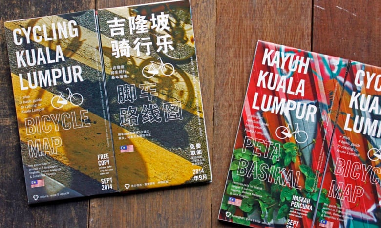
FacebookTwitterPinterest The finished product ... Kuala Lumpur cycling maps. Photograph: Jeffrey Lim

After two years and three drafts, the map was completed in September 2014. It was published in three languages – English, Chinese and Malay – and distributed for free, with a print run of 10,000.

From the beginning, the map had been a grassroots project, crowd-sourced with data from the cycling community. But as word of mouth grew, several local councils contacted Lim to find out more. Now he had a new challenge in front of him: to turn the map into real infrastructure.

“It was interesting to see they took it seriously,” says Lim. While the government had talked up cycling in the past, this had largely been lip service. “It was not at the top of their list. Even though it was stated that, yes, cycling and walking were very important, it was not stated what, where and how.”

The bureaucracy of different government layers was another big obstacle. “Federal government, state governments, departments and city councils – they were all pointing fingers at each other,” says Lim.


Kuala Lumpur City Council has opened a 5km cycle lane, and has approved funds for a further two
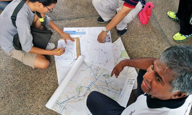
FacebookTwitterPinterest Lim develops the map with volunteers, including members of the Urban Transportation department at Kuala Lumpur City Council. Photograph: Jeffrey Lim

To go beyond paper-pushing, Kuala Lumpur needed a pinch of luck. That luck was its mayor: Tan Sri Ahmad Phesal Talib, who took office in 2012. The mayor happened to be an avid cyclist and he called Lim in for consultation.

On a breezy morning in April this year, Lim and his volunteers cycled alongside the mayor as he inaugurated Kuala Lumpur’s first official bicycle lane. After more than a year of planning, it was finally open: a 5km cycling corridor connecting the satellite city of Petaling Jaya to the historic centre of Kuala Lumpur.

Kuala Lumpur City Council went on to approve funds for two more cycling lanes in other parts of the city, with a total budget of £765,000. Lim has continued to consult with other city councils around Malaysia.


How Christchurch used the earthquake to return the city to its cycling roots

Read more

“I’m happy the map project is over. I’m happy that we have a document and I’m glad that other people find it useful,” says Lim. “I wanted to change people’s perception about cycling. That was the most important thing.”

Of course, it will be a long time before Kuala Lumpur is a bike-friendly city. To date, there has been no directive from the federal government for a cycling master plan. Lim fears that this will hold back long-term infrastructure, especially since city councils rotate their posts every three years.

But, slowly, a cycling culture is growing here. As well as the new cycle routes, residents now enjoy two car-free mornings in the city every month. There’s also talk of a bicycle festival at the end of the year.

“The map connected all these like-minded people and created a strong community,” says Lim. “It started the ball rolling. No matter how small the move, it’s still a stepping stone for the next move – by whoever.”

Ling Low is editor of Poskod.MY. Follow Guardian Cities on Twitter and Facebookand join the discussion


LINK:

http://www.theguardian.com/cities/2015/sep/18/how-crowd-sourced-map-kuala-lumpurs-ideas-cycling


Tuesday, September 22, 2015

Channel 5 News Reporting on Dangers at Crosswalks - Impressive! Plus, Policy Walk 10/2/2015


This is a good representative of why our walkability needs to be high quality.  If you are not an active walker, you may think a simple sidewalk or crosswalk is fine but it takes actually getting out their on foot to see where the design flaws are.  

I applaud this kind of news reporting.  It is accomplishing 2 critical goals:  educating drivers and highlighting design flaws. 


For those who want to be a Pedestrian Advocate and learn more, there is an upcoming Policy Walk on October 2nd, 2015, details below:

Our city is changing every day. All corners are welcoming new people, new buildings going up, new businesses, and new restaurants.   Walking as a means of transportation has become more common and as the use of public transit increases more and more people are walking to and from their bus stops.  Add to this Nashville’s growing recreational walkers and the number of tourists walking about Nashville and at times pedestrians outnumber motorists. 

In 2008, the Nashville Bicycle Pedestrian Advisory Committee (BPAC) was established by an Executive Order<http://www.nashville.gov/Metro-Clerk/Legal-Resources/Executive-Orders/Mayor-Karl-Dean/kd034.aspx> of Mayor Karl Dean to further Nashville's goal of becoming a bicycle- and pedestrian-friendly city. The board includes a representative from every Metro government department, as well as concerned Nashvillians.  When BPAC was formed it joined the already established non-profit Walk Bike Nashville in championing an increase in safe biking and walking as a significant and beneficial mode of transportation and recreation. 

In this spirit, BPAC and Walk Bike Nashville invite you to join us on a 1.6 mile walk showcasing  the “Successes and Challenges” of pedestrians. The walk will highlight what is working well, like the traffic scramble on lower Broadway and lead pedestrian lights and areas that need improvements, in particular the construction closure of sidewalks and bike lanes, which also negatively impact small businesses in their vicinities. 

Details about the policy walk are as follows:

WHAT: BPAC/Walk Bike Nashville’s Successes-And-Challenges Walk, distance is approximately 1.6 miles
DATE and TIME:  Friday, October 2, from 7:30 a.m. to approximately 9:00 a.m.
BRING:  Comfortable shoes
START AND END POINT: Public Square Park, pastries and coffee will be served.
RSVP:  EventBrite

Questions:  Please contact Mary Pat Teague at marypat.teague@vanderbilt.edu or Nora Kerns at nora@walkbikenashville.org


Monday, September 21, 2015

US Surgeon General Gets Involved in Walkability! Should neighborhoods be labled like cigarettes?


You may have wondered why I care so much about walking...well, it comes down to health.  Both physical health and psychological health.  As a physician in Nashville, I meet a lot of people who are unhealthy...and I have real concerns that part of their problem is our built environment.

In Nashville, 75% of our public roadways do not have sidewalks and 88% are described as dangerous for walkers. 

Is it any wonder that people do not walk?


This is in the heart of The Urban Service District in Nashville between the busy Green Hills area and Hillsboro Village.  An easily walkable distance... but would you walk here?


What if we labeled unwalkable neighborhoods like we do cigarettes?


9 Sep 2015 | Posted by Stephen Lee Davis |


The Surgeon General of the United States will unveil a bold new initiative today, aiming to help Americans lead healthier lives — by making walking and physical activity built-in features of more of our neighborhoods.


At a press conference at 10 a.m. this morning the U.S. Surgeon General will kick off a new national Call to Action, urging cities and towns to consider how the design of our roads and public spaces can encourage more walking by making it easier, safer and more convenient. (Tune into the live webcast of the event at 10 a.m. EDT.) To show how significant an issue this is to the Surgeon General, today’s announcement is only the sixth such Call to Action in the last 10 years.
surgeon general warning


According to the Surgeon General’s office, only half of American adults get enough physical activity to reduce the risk of chronic disease, and 10 percent of the preventable deaths in the United States are related to lack of physical activity. Communities that lack safe places to walk are a part of this problem.

What if we labeled unwalkable neighborhoods like we do cigarettes? A similar call from the Surgeon General in 1964 was the watershed event that kicked off a decades-long decline in cigarette use. Could today’s Call to Action do the same for communities without safe places to walk?

What if we put states, cities and towns on notice that streets and roads that are dangerous by design for people on foot or bike are a prime contributor to the obesity epidemic (as well as a contributing factor in an alarming number of fatalities)? What if we prioritized sidewalks and crosswalks the same way we do sunscreen, “no smoking” signs, and preventing underage drinking?

Help us celebrate this important step forward: share today’s announcement with friends and colleagues:

The Surgeon General’s position makes it clear that America needs more than a simple call to “get out and exercise.” We need to build communities where walking is a safe and convenient option — so getting where you need to go can help you stay physically active and healthy.

The good news is that the tide is turning in communities of all types and sizes all over the country. Small towns, rural, suburban and urban areas are reinvesting in their downtown cores and creating vibrant walkable neighborhoods like never before and reaping the benefits of better walking and biking infrastructure. We still need to do more to encourage walking, but there’s clearly huge pent-up demand for walkable neighborhoods and high-quality facilities that anyone can use.

People want to walk, and they increasingly want to live and work in places where it’s a convenient option.

Since Indianapolis’s Cultural Trail, a high-quality biking and walking trail, opened in 2008 the value of properties within a block have increased an astonishing 148 percent. Last week, the Atlanta-Journal Constitution published a special package about the amazing demand for homes near the still-in-progress Beltline project that will eventually encircle the city with trails and transit. Nashville’s metropolitan planning organization recently began considering health criteria as they select transportation projects in the hopes of helping improve the health of residents over the next few decades as they grow. Washington State adopted a Vision Zero plan to reduce pedestrian deaths to zero. Making their vision a reality includes not just educating drivers about pedestrian and bike safety but also re-designing streets and roads to slow traffic and give folks walking and biking safe and attractive facilities to use.

There’s far more to do, though. While these stories are encouraging, the lowest-income neighborhoods across the country are the ones more likely to lack sidewalks, crosswalks or other facilities to keep residents safe.

Help celebrate this important call to action. Share this post and image with your friends and family and colleagues.

LINK:
http://www.t4america.org/2015/09/09/what-if-we-labeled-unwalkable-neighborhoods-like-we-do-cigarettes/


Sunday, September 20, 2015

Unique and Powerful Intervention...With Flowers.


One thing worth fighting is good design.  When it comes to sidewalks and bikelanes, if there is an intrinsic flaw in the design, it can be dangerous, little used, expensive and permanent. 

Consider sidewalks built directly next to high speed roads without any green buffer.  


New 1.4 mile stretch on Harding Place near I-24.  Imagine walking here with small 
children.  Cars are zipping by at 40 miles per hour on their way to the expressway.

One false step and your child is in the road.

Now, imagine if there was a few feet of green buffer - essentially a strip of grass and trees that separate you from the traffic.  Psychologically, this is a significant difference and a much safer (and cooler - literally cooler with the shade created) environment to spend time on foot.

Contrast the above image with the next image that includes a green buffer.
See the difference?

Understandably, the later project, with the green buffer, is likely more expensive but with the permanency of such projects and the cost involved, shouldn't our goal be to build the better designed project  so that people actually use it?

***

I like this guys take on a similar problem.  


A Guerrilla Bike Lane Made With Flower Pots Forces A City's Hand

A cyclist in Boston was sick of a dangerous stretch of road that the city refused to fix, so he took on the matter himself.
For Boston cyclists, Massachusetts Avenue can be a terrifying place to ride—drivers routinely ignore the stripes marking the bike lane and swerve into the path of bikes. After a truck driver recently killed one young bike commuter, the city promised to add some simple barriers to the lane. But they were slow to act.
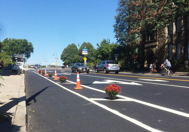
So another bike commuter decided to take on the problem himself: On his way to work in Harvard Square, Jonathan Fertig dropped off a line of orange construction cones and potted flowers along the edge of the bike lane.
"I've been growing increasingly frustrated over the past year," says Fertig, who saw progress on bike infrastructure in the city start to slow when a new mayor came into office.
"When a young woman was killed by a truck driver last month while riding the route that I ride every day it hit me in an unexpectedly personal way," he says. "I was searching for a way that I could do something to amplify to fury that many of us in the walking and cycling advocacy community were feeling."
He picked up a copy of Tactical Urbanism, a book that lays out urban interventions like DIY bike lanes. Inspired, he "just decided to drop some cones in the buffer of the newly installed bike lane. In an instant, cars were no longer using the bike lane as a turning lane."
The flowers have a symbolic connection to the memorial at the corner, where a ghost bike has a flower-filled basket. "Flowers are also beautiful and entirely non-confrontational in their own right," Fertig says. "I liked the concept of using them in an act of civil disobedience. ... I am a child of hippies, after all."
The intervention worked—at least for a small stretch of the road. "It's a joy for 200 feet, until you reach the corner where the terror resumes," he says. "I've had countless people tell me online that the intervention made a big difference."
Less than a week after he installed the cones and flowers, the city came out to add flexible posts (they still have yet to paint the lane green or add green bike boxes, two other promises the transportation department made). But Fertig, like many other cyclists in the area, thinks the lane could be much safer—and probably should be fully separated with a permanent barrier.
He also wanted to draw attention to how slow the city was to act. "While re-engineering the intersection in any capacity within a month would typically be considered a very quick response, they only did so because of the fatality, and it was thus reactionary," he says. "The city—and the advocates that helped crunch the data—have known for two years that the intersection has one of the highest crash rates for cyclists and pedestrians in the whole city, yet they had done nothing."
As a continuing protest, he added more flowers to the new flexible posts.
He's also raising money to add more interventions down Massachusetts Avenue—which he calls the most dangerous stretch of road in the city. In the first two days, the campaign raised more than $3,000.


LINK: